CHAPTER 1:
CONCEPTION
Brighton’s rise to prominence is a long and fascinating tale of social and political influences and necessities. From the town’s humble start as a small seaside fishing village to the enormous, internationally renown, twin centred city it has become; Brighton has always held favour and interest for any visitor. There is something for everyone here, from the austere to the extrovert, from laid-back to laid bare, Brighton has it all.
Two key events helped put Brighton (or Brighthelmstone as it was known originally) on the map. The first of these was that a certain Dr. Richard Russell set up his practice in the town in 1754 and extolled the virtues of the seawater as having great medicinal properties, which popularised bathing and therefore greatly increased tourism to the town.
The second was that the Prince Regent (George IV) heard of Doctor Russell's work and was recommended to "partake of the benefits of salt water bathing". He quickly fell in love with the town and comissioned the building of his grand home, The Royal Pavilion, at the Old Steine in the town centre. That the town had gained royal patronage was certainly a boost to the town and certainly served to increase its status.
As a highly fashionable and bohemian place to be seen, Brighton would have had to adapt quickly and proficiently to a huge increase in popularity over the next 250 years, but no-one could ever have forseen the changes that would come about if the town was to become more accessible to the curious traveller.
Back in 1847, it would have taken 7 hours on a stagecoach to travel from London to Brighton and many of the coach companies competed fiercely for speed and custom. Many of them offered a full refund if punctuality was not achieved. As a result of this need for speed and punctuality, 15 horses employed on a particular route died a horrific death as a result of their exertions in the space of a week, causing the authorities to step in.

ABOVE: The Royal Pavilion, home of The Prince Regent, George IV. Doubtless, Royal ascent put Brighton on the map and helped boost the town's popularity and status.
By 1822 there were 60 stagecoaches a day between London and Brighton and the journey time had decreased to between 5 and 6 hours. New roads en-route had straightened the route and thus shortened the distance.
As the town grew in both size and popularity, a regular ferry service was established to Dieppe and was facilitated by the building of a large jetty or “Pier“ into the sea to a sufficient depth for the steamer to dock. Until the construction of the first of these, The Chain Pier, intending passengers were transferred to the steamer by rowing boats.

ABOVE: Brighton’s Chain Pier undoubtedly added impetus to the argument for a rail link to London. The pier was used primarily as a landing stage for a steam packet service to France. With the advent of the London to Brighton Railway, it would create a key route from London to Paris. This photo is part of the Chris Horlock Collection.

ABOVE: This photo is more or less self explanatory! As the town grew in both size and popularity, a regular ferry service was established to Dieppe. This photo is owned by coldean.org.uk
It is surprising to note that plans were actually inaugurated to construct a small harbour area to the east of the Chain Pier with the harbour’s eastern arm attached to the pier itself. John Harman, the then chairman of the LBSCR proposed that the board of directors assign 300 pounds to the project. This paid for 3 sections of the breakwater to be moored to the pier. Sadly, the plan never took off. The 3 segments were towed to Shoreham harbour, one section breaking away and ending up washed up on the beach at Hove. In Later years when the Newhaven Railway was established, Newhaven was developed as a main route to France. Sadly, Brighton would not have a harbour until the construction of the Brighton Marina in 1978.
As the popularity of sea travel to France and beyond increased, so did proposals for a rail link with London. The port of Shoreham some 6 miles west of Brighton was a natural harbour and had established itself as a thriving ship-building centre. As a shingle bank encompassed the port of Shoreham, there was an ever-present problem with the build-up of silt and this caused the harbour to become totally unusable for shipping.
Therefore, in 1816, the harbour was improved and modified and also lead to proposals for a rail link between the new facilities and Brighton.
In 1823 one William James made a very early proposal for a railway between London and the Sussex Coast. His idea was to connect London with the ports at Shoreham, Rochester and Portsmouth. According to his proposals, the Sussex branch would have terminated just east of Shoreham (approximately at Southwick in modern times) which would have been the eastern most end of the harbour at that time. Sadly, Mr. James’s idea never came to fruition.
Two years after Mr. James, a company under the heading of the Sussex, Surrey, Hants, Wilts and Somerset Railway Company commissioned Mr. John Rennie to research and survey routes from London to Brighton as part of the ambitious plans portrayed by its title! The company did not survive but if it had, would surely have given rise to a supreme rail network. It is interesting to note that one of the routes proposed by Mr. Rennie was actually accepted as the preferred route of the London to Brighton Railway.
By
1833, no less than 6 projects for the London to Brighton route were being considered
by Parliament. On
A
line proposed by Robert Stevenson, which ran via Henfield and Horsham, found
considerable favour at first, but was opposed by the powerful aristocratic
residents of Brunswick Square who objected on the grounds that the terminus
would have been too close to their homes. This is because Stevenson proposed to
build the terminus on
By
1836 favour had veered towards Mr. Rennie’s line as being the most direct
route. It would have terminated at a site near
One proposal, the London & Brighton Railway (hereafter L&BR) surfaced following an act of Parliament in 1837. This proved to be a lengthy and expensive battle to find the most direct of the 6 routes proposed. The idea of the LB&R scheme was to build a line from a junction with the London & Croydon Railway (LCR) at Norwood, utilising the existing LCR tracks for part of its route: that which is Londonward of that point. However, due to an awkward anomoly insisted upon as part of the Parliamentary red tape surrounding this scheme, it was decreed that the new line should share the part of the proposed route between Croydon and Redhill with the South Eastern Railway (SER) main line to Dover. This one stupid proposal gave rise to 60 years of disputes between the two companies!
Arguments for and against the 5 schemes and their various merits and pitfalls continued for another 12 fruitless months. Back in Brighton things were remarkably confused and the general consensus was that any line to London would be better than none at all.
Eventually
a compromise was met and the Brighton Vestry proposed a plan, which adopted
Stevenson’s approach via Henfield but took the line through to Rennie’s site
for the terminus.
However, while Brighton had appeared to make a decision, Parliament had decided that all these arguments couldn’t continue indefinitely and had appointed an engineer from the Ordinance Department to produce a definitive report on the matter. The Vestry was alarmed by the prospect of yet more delay but the Government engineer acted swiftly and to the great relief of Brighton residents, gave his casting vote in favour of the “direct line”.
The Direct line had more in depth civil engineering and constructional problems to overcome than Mr. Stevenson’s route but provided better opportunities for the provision of branch lines at convenient points, which would radiate east and west into the majority of Sussex .
Finally, to everyone’s great relief, the Engineer’s report was published in June 1837 and on 15th July of the same year, the Bill for the London & Brighton Railway Company received Royal Assent.


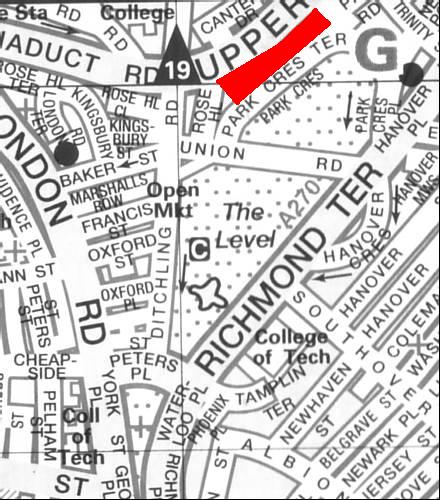
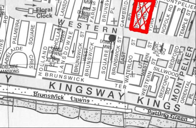
ABOVE: Two of the proposed sites for the Brighton Terminus. The Level (on the left) is a little closer to the final site (final station site is just off the bottom left of the map) and the proposed site shown on the right was abandoned because of its proximity to Brunswick Square: the residents whined until it was withdrawn. NIMBY was alive and well even then! This would have created a spectacular corridor to the beach via Brunswick Square. Maps owned by Estate Publications, all rights reserved.
Eventually a compromise was met and the Brighton Vestry proposed a plan, which adopted Stevenson’s approach via Henfield but took the line through to Rennie’s site for the terminus.
However, while Brighton had appeared to make a decision, Parliament had decided that all these arguments couldn’t continue indefinitely and had appointed an engineer from the Ordinance Department to produce a definitive report on the matter. The Vestry was alarmed by the prospect of yet more delay but the Government engineer acted swiftly and to the great relief of Brighton residents, gave his casting vote in favour of the “direct line”.
The Direct line had more in depth civil engineering and constructional problems to overcome than Mr. Stevenson’s route but provided better opportunities for the provision of branch lines at convenient points, which would radiate east and west into the majority of Sussex .
Finally, to everyone’s great relief, the Engineer’s report was published in June 1837 and on 15th July of the same year, the Bill for the London & Brighton Railway Company received Royal Assent.
