1. Northern end of New
England Street, Fyffe’s
Warehouses & Pay
Office.
This area is the northern-most
point of The Works Site and incorporates the track bed of the Lower Goods Line,
the Pay Office and Works Main Entrance & Elevated Extension and the
surrounding warehouses facing New
England Street.
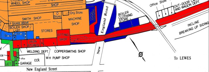
ABOVE: This map shows the area concerned, relative to the zenith of The Works’ life. The different colours show the level of accessibility available to the site’s components between 1980 and 2003 prior to redevelopment. The red areas are those that were easily accessible (the pay office, Lower Goods track bed between New England Street and Lovers Walk Depot & the original access path to the MPD depot). The green areas are derelict and not easily accessible (the stairway to the footbridge access to The Works and the top storey of the pay office). Blue areas represent those that are overgrown with uncontrolled vegetation and finally the orange areas, which represent parts of the site that were removed when the car park was originally constructed.
The car park has consequently been removed in the current redevelopment. Note that the Iron Store and Welding depot were in an overhead extension to The Works and they were built out over the Lower Goods access line. Access in this context infers that it is still possible to walk through where they stood, that the supporting pillars are still intact and that the retaining walls to the north side of the track bed (facing the pillars) are still intact, even despite redevelopment. A small section of track bed and supporting walls and pillars was removed late in 2005 to construct a temporary access road to the car park while the original access ramp was demolished. This was carried out in the area bound by the Coppersmith Shop on the map and was constructed as a continuation of Cross Street. The Boiler Clothing Store was removed as part of Operation New look, but a section of the foundations are still visible from New England Road.
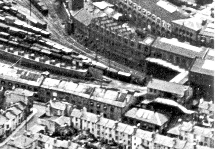
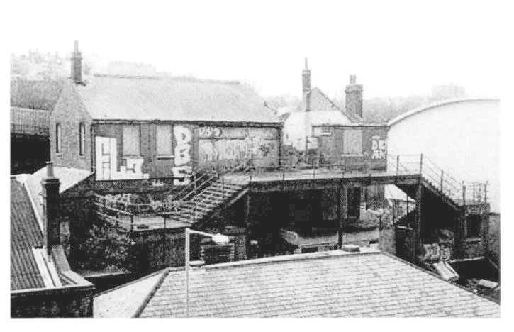
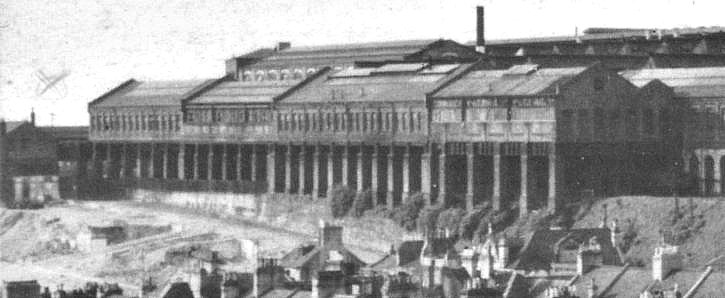
ABOVE: This aerial photo shows the part of the site concerned in this chapter. The Pay Office, footbridge access and staircases can all be seen on the right hand side of the picture. The row of warehouses that run diagonally from middle left to bottom right are those that form the frontage to New York Street (now New England Road). These would have originally been the old Fyffe’s Bananas Warehouses at the time this photo was taken.
The Lower Goods Line can be seen fanning out from under the walkway and into a multitude of sidings. To the immediate left of the footbridge is the southern end of the extension on its piers, built out over the track. Below that, in the far right bottom corner are a few of the houses mentioned elsewhere in this chapter, that were cleared away when New England Street was widened and modernised. The Church of Christ the King (C.C.K.) now stands on this spot.
The curved wall of The Works Buildings beyond the walkway later formed the boundary of the car park before development, leaving the walkway as a precarious dead end for some 20 years before redevelopment. The majority of the sidings in this picture were either fairly accessible or overgrown between 1970 and roughly 2002 and were popular with dog walkers so access was fairly easily gained.
The squat, single storey building just left of the to centre of the picture is where the access ramp to the car park would have curved across the goods line and descended alongside it to the top left of the picture. It is interesting to note that the car-loading ramp in this photo (diagonal wall with white square objects on, centre left) formed the base of a Post Office van parking area for about a decade and a half, prior to redevelopment. The space below the drop and behind the warehouses would later be part of the Clifford’s Auto Factors car park with the wall acting as a divider for the 2 respectively.

ABOVE: This diagram shows the usage of the site detailed immediately prior to closure and redevelopment of the site. The Fyffe’s Bananas Warehouse has become John’s Camping, Martha’s Barn Furniture and Clifford’s Auto Factors.
C.C.K., Brewers Decorating Supplies, the Tribunal Courts & Geo Richardson’s Scrap Merchants all came about with the widening and redevelopment of New England Street in 1962.
This map is not to scale and is meant only to represent the layout and usage of the site components.
ABOVE & BELOW: These two pictures show
the Main Entrance to The Works and the Pay Office in 2003, just prior to the
site clearance to make way for the New England
Quarter and Citypoint redevelopment. John’s Camping can be clearly seen in the
foreground, occupying part of the former Fyffe’s Banana Warehouses complex. The
photo below is taken from a more elevated position on the staircase of New England House and shows the access staircase in more
detail. CCK looms large on the right.
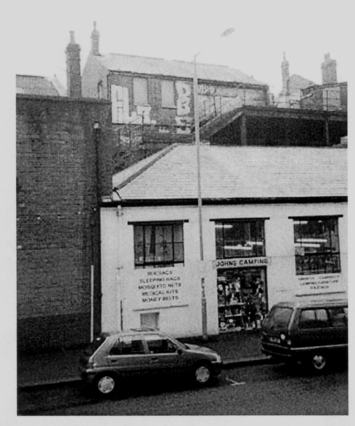
ABOVE: John’s camping again, this time from street level in 2003.The wall of Martha’s Barn Furniture can be seen to the left.

ABOVE:
The Pay Office & Works Entrance viewed from the rear. The footbridge was
the original access to the Site, crossing the track bed of the Lower Goods
Line, underneath. New England House can be seen top
right. This photo is from the Isetta Owners Club website.

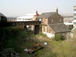
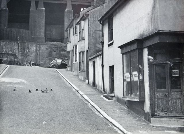
ABOVE & LEFT: These photos show the rear of the Pay Office & Works Entrance, looking along the path of the Lower Goods Yard Track bed. The gateway seen above joins onto the car park next to Clifford’s Auto Factors and the rears of John’s Camping and Martha’s Barn Furniture can be seen on the right. The curved roof of the CCK building peeps round the side of the Pay Office. (Picture Above courtesy of The Isetta Owner's Club Website).
Note the edge of the walkway to the original Works Access top left, also the raised goods platform at the rear of the warehouses. The Walkway to the Works Building is shown in detail BELOW. (The photos left and below are both borrowed from an unknown Flickr picture set and are used here for illustrative purposes only - if they happen to be yours, please let me know and I will credit them to you with a link to the original location!)

Below:
Martha’s Barn Furniture. Clifford Auto Factors can be seen far right and the
post office car park and Clifford parking is on the left.

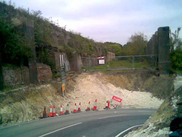
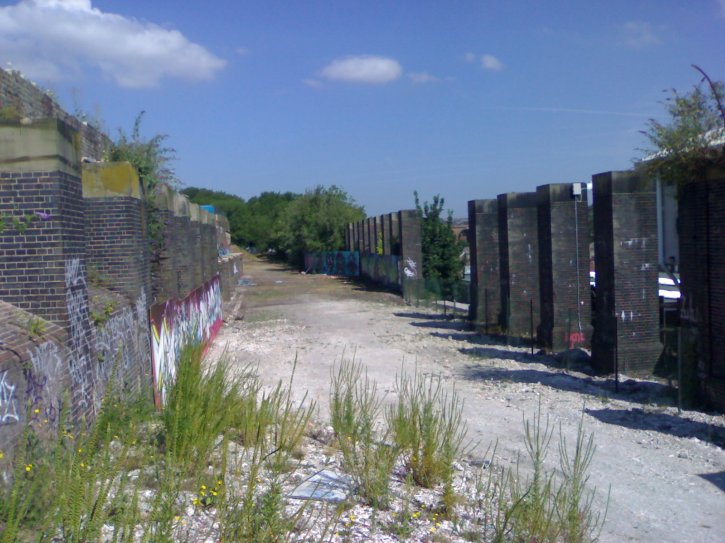
ABOVE: This photo shows the track bed for the Lower Goods Yard looking due north. The retaining walls and pillars are still there and relatively unchanged apart from the temporary access road built (May 2005) whilst demolition of the access ramp for the car park was being carried out further south opposite Station Street. This joined onto Cross Street on the map (to the right of the photo) and ran parallel to Boston Street.
The map shown BELOW covers the overall site in the present day and shows the location and direction of the photograph above in red.

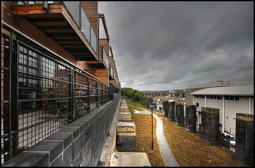
This photo (ABOVE) shows the track bed in early 2006 reinstated after
the removal of the temporary car park access ramp. The track bed has been
cleared and contractors are in the process of laying pathways for the “Green
Corridor”. The only signs from this side that anything had been changed are
shown by the slightly conspicuous gap in the pillars, 2 of which had to be
removed. The changes are more visible from the Boston Road
side. The top of
this retaining wall (on the left) was knocked back to just under the
tops of
the arches in December 2006 as a level platform for the development of
sustainable "eco-houses" that are to be built on this corner of the
site. The same view is shown in December 2008, nearing completion,
(BELOW).
BELOW: The same view in July 2009, all but completed.

This photo (BELOW) shows the view in the opposite direction in late 2006,
taken from the Goods Line Bridge across Old Shoreham
Road at the north end of the site. In January to April
2007, the tops of these arches were demolished and the pillars were rebuilt
into retaining walls as part of a huge college building constructed immediately
above them, as mentioned above and detailed elsewhere in this chapter.
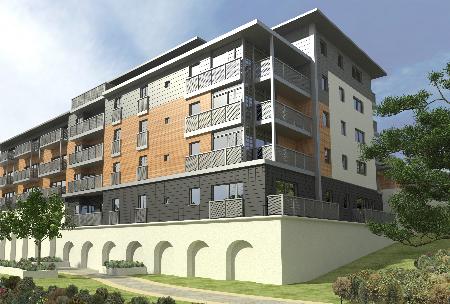
BELOW: The finished article in 2010 (this is a computer generated image)
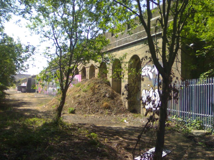
ABOVE: This photo shows the pillars and the massive extension to The Works that they supported. Note the chalk slopes in front of the pillars: this had been a feature for many years and explains why there is a steep wall along the length of Boston Street on this side. The slope here was so steep as to be unusable and was caused by the construction of the immense plateau on which the entire station site sits.
Boston Street and Cross Street are now in the area of chalk, which was
mostly an area of residential housing until 1962, when the entire area was
rationalised and unfortunately left us with the bland and uninteresting
thoroughfare which makes up the northern end of New England Street in the
present day. The road was widened to accommodate business traffic and was used
to relieve traffic from London Road until it was
severed as part of the current redevelopment and traffic diverted through the
new road scheme around Billington Road. With the
widening of the road and demolition of surrounding houses, a thriving community
was lost, as many perfectly serviceable houses were demolished.


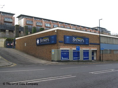
ABOVE: This Photo shows the support pillars from New England Street on 24th April 2007.The CCK Building and Brewers can be seen to the left and right and the tops of the pillars just poke over the top of Brewers. The building under construction in the background is to be a Foreign Languages College.
BELOW: Although not clearly visible in the top picture, the height of the arches behind the pillars has been lowered slightly to act as a retaining wall for a row of terraced “eco houses” in front of the main college building, the arches and pillars can be seen more clearly to the right of the bottom picture. The Building under construction to the left will be a hotel for the “Jury’s Inn” Group.

ABOVE:
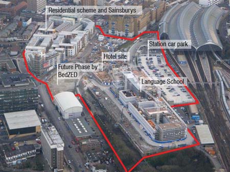
This aerial photo shows the majority of the site as it appeared in early 2007.
The College Building (shown here as “Language School”) can be seen clearly
bottom right and the gap between the college and the pillars where the two
cranes are will soon become a plot for Eco Friendly terraced housing, which
will sit on top of the brick pillars which originally supported the Works Extension
above the Lower Goods Yard Track bed. The area marked as Future Phase by BedZED
will become the “One Brighton” development, seen later in this chapter.

This photo (ABOVE) shows the cycle path under construction in July 2006, which follows the route of the Lower Goods Yard Track bed looking north. Work has yet to commence on the College building and Hotel site seen in the previous picture.
Below: College building in early stages of construction on 24th July 2006.
1.Top: looking east from the roof of the Car-park
2.Bottom: looking northwest from Billington Way.


ABOVE & BELOW: The Jury’s Inn Hotel in its finished state; The architectural drawing viewed from the east (above and in the flesh just below it with my wife looking cold and irritated by me taking photos!!) and the western frontage in January 2008 (below). The blue neon ring on top is very useful as a landmark and navigation aid because it can be seen from a remarkably long way off.


ABOVE & 2 BELOW: These two views show the Language College building viewed from street level. The impressive glass section is illuminated in the evening and, like the Jury’s Inn, can be seen from almost anywhere in the city.
The glass area encompasses an atrium, as the left wall appears to be either self contained accommodation for students or study rooms.
Bottom: The College Buildings and Jury’s Inn looking from the roof of the Multi Storey Car park, looking north-east.


ABOVE & BELOW: This photo (above) shows New York Street (later New England
Street) before it was widened in 1962. All the
buildings in the photo here were demolished, despite being perfectly sound
structures, and a thriving community was lost. The picture below shows the same
view in the present day; it is sterile and bland & has lost all of its original
character, although the City Point development is slowly returning the area to
dwellings. Note the small building next to C.C.K. to the far left of the
picture. This is part of the stairway to the pay office and the main entrance
to The Works.

ABOVE & BELOW: These two shots of Boston Street off New England Street are taken roughly 80 years apart and show how the area has changed beyond all recognition and yet the pillars that supported the massive Works Extension over theLower Goods Line Trackbed are still in position and pressed into a new use supporting the development of the Eco Houses and as an impressive backdrop for the Green Corridor between Old Shoreham Road and Stroudley Way. The terrace houses seen above were demolished in 1962 to 1964, when the New England Street area was completely demolished and redeveloped. Brewers Painting and Decorating Centre now stands on the site, along with its car park to the rear.